Redirected flood waters leading to unintended consequences
Study reveals land conversion from wetlands to agriculture leads to flooding

An intricate system of basins, channels, and levees called the Headwaters Diversion carries water from the eastern Missouri Ozark Plateau to the Mississippi River south of Cape Girardeau. The system protects 1.2 million acres of agricultural lands in southeast Missouri from both overflow from the Mississippi River during flooding events and from Ozark Plateau runoff. Historical and more recent extensive rainfall and subsequent flooding prompted University of Illinois researcher Ken Olson to look more closely at where the excess or diverted water goes.
“There is a need for additional floodwater storage in the confluence area of the greater Ohio-Mississippi Rivers,” says Olson. “A regional effort on both sides of the Ohio and Mississippi Rivers is needed to strategically identify floodplain areas that could provide temporary water storage and policy incentives for landowners of low-lying lands to profitably invest in crops and income alternatives.”
U of I reports that Olson and his colleagues are studying the levees, diversions, and floodways, which for the past 200 years have allowed land conversion from wetlands to agriculture. “It has substantively altered the hydrologic cycle of the region,” he says. “The Little River levee and Little River Drainage District Headwaters Diversion channel built in the 1910s successfully permitted the drainage of the 1.2 million acres Big Swamp in southeast Missouri. However, it also had the unintended consequence of increasing the peak flow of Mississippi River water south of Cape Girardeau through the Thebes gap and south to Helena, Arkansas, a distance of approximately 360 river miles.
“When the Ozark uplands and Francois Mountains experience above-average rainfall for extended periods of time, the additional runoff transported by the diversion channel increases the chances of Mississippi River levee breaches south of Commerce, Missouri, and adds to the peak river height at the confluence of the Ohio and Mississippi rivers.”
Olson says the increase in Mississippi River peak flow placed additional river pressure on levees and led to increased flooding, especially during the floods of 1927, 1937, 2011, and 2015-2016.
“The Kentucky, Illinois, and Missouri farmers’ and land owners’ response to the additional volume and height of the Mississippi River from the diversion channel valley and the prevention of the Mississippi River floodwaters from flowing into the ancient Mississippi River valley and Big Swamp was to build floodwalls and levees,” Olson says.
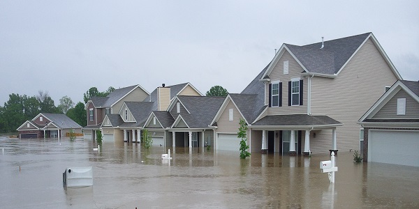
After the 1915 flood, Cape Girardeau built a floodwall to protect the city. Likewise, after the Great Flood of 1927, Cairo built a floodwall, strengthened levees, and created the Birds Point-New Madrid floodway. Missouri farmers built the Commerce Farmer levee that failed in 2011. Kentucky farmers built the Hickman levee — strengthened later by USACE — and did not fail.
“Illinois farmers built the Fayville-Len Small levee that breached in 1993 and 2011,” Olson says. “It breached a third time on Jan. 2, 2016, when the Thebes river gage reached a record 47.7 feet –14.7 feet above flood stage. As of Jan. 5, the farmland, homes, and roads were still under floodwaters.”
Olson says climate scientists predict a continued pattern of extreme rainfall events in the upper Mississippi River region. “This suggests that unexpected above average rainfall events in the Ohio and Mississippi River basins will continue to increase the frequency of extreme flooding events on these Great Rivers.”
Olson is a researcher in the Department of Natural Resources and Environmental Sciences in the College of Agricultural, Consumer and Environmental Sciences at the University of Illinois.
— Read more in “Missouri Ozark Plateau Headwaters Diversion engineering feat,” Journal of Soil and Water Conservation 71, no. 1 (January-February 2016): 13a-19a (doi:10.2489/jswc.71.1.13A)